- Specialists in Erosion Control -
![]()
- Specialists in Erosion Control -
[ About Us ]
[ Our Services ] [ Our Work ] [ Hall
of Shame ] [ News
]
[ Contact ] [ Tanzania ] [ B.U.F.T ] [ Links ] [ Sign
our Guestbook ]
A Detailed Report on our Work in Tanzania
HEALING THE RIFT
Footpath repair work on the Dareda Section of the Rift Valley Escarpment
For FARM Africa - Babati Agricultural Development ProjectMarch 1996 - December 1997
Author: Andrew Carling, Mountain Path Repair International
Sunindale, Millans Park, Ambleside, Cumbria LA22 9AG, UK
Tel: +44 (0) 15394 34392
Email: [email protected]
CONTENTS
- Geographic features
- Causes of erosion
- Use of footpaths
- FARM Africa's response
- Consultant's terms of reference
SUSTAINABILITY
UPDATE JANUARY 1999
FARM Africa is a British based NGO, specializing in rural development, with projects throughout East and Southern Africa. It has one activity in Tanzania; the Babati Agricultural Development Project, which started in 1992.
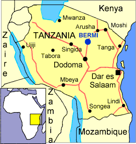
The project is based in Bashnet division, Babati district, some 200km Southwest of Arusha (see map). The project runs eight different and interrelated programmes.
The project has two broad aims;
Achieve sustainable improvements in the standard of living of the rural community through improved agricultural technology practices and land management.
Enhance community and farmers capacity to solve their economic and related social problems and manage their own development, including women in this process.
One aspect of their operation is the Escarpment Reforestation Programme. This component started when local communities approached FARM Africa for assistance in conserving sections of the Rift Valley escarpment, which passes through the project area.
Geographic features
The escarpment is about 350m in vertical height. There are deep ravines carved by seasonal water floe. Only one of these watercourses flows all year. The lower slopes are steeper, and more eroded. Rainfall is 700mm - 1,000mm per year.The top of the escarpment is the fringe of the Nou forest reserve.
There are two main factors; overgrazing and deforestation. Individuals interviewed suggested that, initially, deforestation went very slowly. One of the first settlers in the area (previously part of the territory of the pastoralist Barabaig) in the 1920's or 1930's explained how people chose to live a little way up the escarpment, open up the fields at it's foot, and keep cattle further out on the plains. They would use cleared trees for firewood and timber.
Mzee Cosmas, an elderly Bermi resident remembers that in 1948 the escarpment had forest on the top, good tree cover on the slopes and pasture below the trees.
In the 1960's there was still good tree cover and abundant wildlife such as hyena, leopard, elephant etc.
Villigisation in the 1970's (after independence Tanzania gathered people in newly created villages, often by force) increased the population of the area dramatically and created the villages of Bermi, Seloto and Dadeda Kati. The vastly increased demand for building materials and firewood, together with the increased numbers of cattle led to a rapid deforestation of the escarpment.
The three main trading centres of Bermi, Seloto and Dareda Kati lie at the base of the escarpment. Villages on top of the escarpment are more scattered, with most people living in isolated households.
The vehicle road connecting these villages takes a 10km detour to ascend the escarpment. Therefore to sell crops, attending the local hospital or church (located in Seloto village) the footpaths are the villagers only option.
There is some public transport using the road, however the majority of residents simply cannot afford it.
A consultant from the ODI (now DFID, Department for International Development), Gill Shepherd, was commissioned to identify and plan a programme to assist escarpment reforestation (Restoring the Landscape. Proposals for a Participatory Approach to Managing the Dareda Escarpment, ODI April 1995).
During this research villagers stated their concerns about the state of the footpaths. The main problems raised were; that the paths were becoming gully's, numerous shortcuts had appeared, and that the erosion made the paths too slippy, especially in the rainy season, to be used safely.
FARM Africa approached the National Trust, Europe's largest and oldest conservation charity for advice. It was decided to employ one of their Team Supervisors to train village groups.
The National Trust has evolved methods to solve path erosion using locally gathered materials, mainly stone. These techniques have been in use for over 2,000 years and are known to be long lasting, easy to maintain and having a simple design. No special tools are used.
Consultant's terms of referenceThe path work undertaken by the consultant will be restricted to the areas of the Rift Valley escarpment that are described in the Reforestation proposal.
The main objective for the consultant is to build local capacity for footpath construction, footpath repair, relevant drainage work or gully rehabilitation to facilitate sustainable traffic of pedestrians or animals up and down the escarpment without damage to it or to land or property at the base of it.
This work will be achieved through technical advice and on the job training of village work parties or representatives while rehabilitating selected paths or associated works.
To achieve this aim the consultant will work closely with the village, the village escarpment committee and any work groups provided by the village. The work will be done in close liaison with BADP Agroforestry and Escarpment Reforestation Officers.
Where escarpment committees do not exist, the consultant should make every effort to establish them.
METHODOLOGY
Village organizationEach village now has an Escarpment Committee (EC) who are responsible for decisions relating to the escarpment. This was a precondition for the consultant to begin work programmes with a particular village. These decisions are forwarded to the village leaders and subvillage representatives who discuss and vote weather to accept the decisions.
In all cases arrangements were made through the relevant EC's. Where EC's hadn't been formed it was decided not to undertake footpath rehabilitation until such committees were functioning. This provided a formal framework for decision-making and planning, and was perceived as the best forum to ensure community participation.
To set up the rehabilitation work ALL decisions were made by the EC's. They decided to use community workdays (each household 'donates' labour one day per week for activities beneficial to the community). To spread training as widely as possible each subvillage was to provide labour in rotation.
Stone is the consultant's preferred medium. It is available on site free of charge and lasts forever. There were no material or maintenance costs to the project or community.
In particular, three methods were used;
1. Stone lined drains, which outlast earth drains and provide a permanent hard surface resistant to erosion. Their design means that they are largely self-cleaning.
2. Stone path is created by burying stone to create a hard path surface, and by stepping the stone, gradients can be eased.
3. Gully walls protect the bottom of a gully from further erosion, and, with sediment carrying water flow, act as a brake thus forcing the sediment to be dropped behind the wall filling the gully.
Training methodologyAfter working with a village for a few weeks the consultant eased off directing the work and began asking "Where should the next drain go?" etc. From the villagers response it was clear that, by suggesting the right place, and explaining why they thought that was so, that they understood the principles behind the work. All training was hands on and practical.
After working with a village for a few weeks the consultant eased off directing the work and began asking "Where should the next drain go?" etc. From the villagers response it was clear that, by suggesting the right place, and explaining why they thought that was so, that they understood the principles behind the work. All training was hands on and practical.
The aim was to train people on the methods of path repair and construction by practical example so that they can continue to repair footpaths after the consultant's departure. The consultant was responsible for structural intervention, and the revegetation was the responsibility of BADP project staff.
At the request of the relevant EC's four paths were repaired as part of the training process; two in Bermi, and one each in Dareda Kati and Seloto. Each path demanded a different approach.
Main path, Bermi. A catastrophic flood caused the erosion in 1968. There is a large area (100m x 30m) which is deeply rutted and bare. Some ruts are 2m deep. There is little stone, so earth drains were needed.
Minor path, Bermi. Erosion is characterised by a long vertical rut throughout its length, causing water to flood straight down onto smallholdings at the escarpment base. Stone is sufficient for the required drainage measures.
Hospital path, Seloto. This is the busiest of all the paths in the vicinity. It is mainly used for trade and the movement of goods, and by stretcher-bearers taking patients to Dareda Mission Hospital in Seloto village. The path was unstable for the bearers, and unusable in the rainy season.
As there are smallholdings on the lower third of the slope, drainage measures were confined to the upper slope. Stone path was constructed in key places.
Qameyu path, Dareda Kati. The path is basically a gully. Water erosion has been compounded by the path's use as a mule trail. Once again smallholdings encroach on the lower sections of the path. Drainage measures utilise natural watercourses on either side of the path. Gully reclamation techniques were used adjacent to the path and adapted for use on the path itself.
Bermi benefits from a dynamic and honest village government and has an excellent record of community work both within, and outside of FARM Africa programmes.
Work began on 1/6/96. Each of the three subvillages provided labour on rotation for three working days per week. The average attendance was 12. A total of 156 individuals received training. 10% of work parties were cancelled for minor reasons (e.g. Death in village, public holidays).
2km of path were improved. 50m of drains were constructed. 200m of earth drains were dug and 15m of stone path built.
Seloto has had a divided and inefficient village government for years, and a recent change of leadership faces an uphill struggle. Communication between leaders is very poor and little or no community work is undertaken.
Work began on 1/4/97. Six of nine subvillages provided labour on rotation for two working days per week. The average attendance was 6. A total of 119 individuals received training. 59% of work parties were cancelled, usually due to poor communication within the village.
1km of path was improved. 20m of drains were constructed. 100m of earth drains were dug and 80m of stone path built. Some gully reclamation work was undertaken.
The situation in Dareda Kati is similar to that of Seloto. However a change in leadership is slowly improving the situation. There is an element within the village that is very keen to undertake path improvement, and other community work.
Work began on 1/10/97. Each subvillage near the escarpment provided labour for two days per week. However, the community asked for the days to be increased to three per week when they heard that the consultant was due to leave in a month's time. Naturally this was accepted. As the work progressed attendance rose from 6 per day to between 12 and 25.
A total of 60 individuals received training. 30% of work parties were cancelled, but this dropped to 10% after the villagers learned of the consultant's departure date.
1.5km of path was improved. 100m of drains were constructed. As most of the path was a gully, the work was mainly concerned with ameliorating this.
Evidence of impacts was collected from village leaders, the general community and by questioning people using the paths.
No negative comments were received. The work was described as 'good' or 'very good'. The methods were new to the area and were considered to be appropriate by all.
Mzee Cosmas, a 77 year old resident and village elder of Bermi, says that it used to take him an hour to walk up the escarpment. It now takes him 45 mins.
Several people stated that elderly residents are now able to use the path for visiting relatives etc. Prior to the work it was impossible to use the path safely.
Communities on top of the escarpment use the Seloto path to carry patients to Dareda Mission Hospital. They are unanimous in their view that the path is now easier and safer for stretcher bearers.
Quamayu inhabitants (a village at the top of the escarpment) were asked for their views. They stated that the improved path is:
Safer, in that elderly residents can now use the path
Safer for load carrying
Faster and easier to walk on. There is much less danger from injury from slipping or falling.
Bermi residents, at the base of the escarpment, state that the risk of flooding has diminished substantially.
A survey was carried out in December 1997 for the hospital path, Seloto.
32 people were questioned as they used the path; 22 male, 10 female.
- Why are you using the path?
16 ( 50% ) were travelling for trade purposes only.
16 ( 50% ) were combining trade with visiting relatives, travelling onwards from Seloto bus stand or bringing patients to hospital.
- How often do you use the path?
21 ( 66% ) use the path at least twice a week
( 25% ) use the path once a month or more
( 9% ) use the path irregularly
- Has the repair work improved the path? How?
( 100% ) say the path is better after the work
( 100% ) find it easier to use
( 100% ) say it is safer to use, particularly when carrying a heavy load
- Was the repair work necessary?
( 100% ) say it was.
- Do you have any suggestions about the work?
( 44% ) say the work should continue higher up the path
( 9% ) say the drains need stabilising on the upper slope
( 9% ) recommend planting trees
- Where have you set out from?
Number of People Village Distance
(origin Seloto)14 Endaw 7km 7 Bashnet 10km 2 Arri 14km 2 Arusha 210km 1 Dongobesh 60km 1 Loxomanda 60km 3 Dareda Kati 8km 1 Madunga 12km 1 Babati 37km At the time of the survey ( 9am, on a Wednesday ) the rate of pedestrian traffic was around 60 people per hour. This figure is subject to variation; e.g. less people use it in bad weather, or during the rainy season, but more use it on market days or to attend mass at Dareda Mission.
80% of the people moving downwards were carrying loads, often in excess of 60kg.
RECOMMENDATIONS
Revegetation
There has been little revegetation work as yet. The minor path, Bermi needs no work as natural regeneration is sufficient. The path is little used as the vegetation surrounding the path is now so thick that people prefer not to use it because of the danger of hyena hiding in the bush.The major path has had some replanting work and landscaping. This needs to be completed.
Hospital path, Seloto needs extensive replanting on both sides of the path and on bare areas adjacent to the path.
Dareda Kati path could benefit from replanting work, however natural regeneration could be sufficient.
There is no preferred species for revegetation, as a mixture of available grasses, sisal and seedlings would be appropriate.
All drains need to be cleared of any debris that could prevent the clear flow of rainwater, before the rains start, and checked after periods of heavy rain. Earth drains need to be monitored carefully. Until they have good vegetation cover they could be damaged.
There is scope for widening the present use of conservation structures, for example, where irrigation ditches cross trails within the villages and adapting stone drains to protect standpipes.
The consultant is confident Bermi will continue the work when needed, but is less confident about Seloto and Dareda Kati until conflicts within the respective leadership is resolved. Therefore it is strongly recommended that FARM Africa staff encourage the revegetation work as a priority.
Training has been widespread throughout the communities and those trained are experienced in the methods and understand the principles behind them.
One member of the community attended every work party. He has been approached by villages not within the project area to assist them.
Since the consultants departure the villages took the full force of El Nino. The destruction was massive, with the area virtually cut off for six months. For example, the journey to Arusha normally takes about five hours. During El Nino it took 2 - 3 days.
Many bridges were destroyed, all rivers deepened and widened. There were several major landslides and much other environmental damage.
The footpath work was virtually unaffected by this. The villagers at the escarpment base in Bermi credit the path work for halting any landslides, which would have destroyed their homes and fields.
The hospital path remained in use during this time. There is clear evidence that more people are using the path to get to hospital. If the path is unusable, then the road is the only way to get to hospital. As people can't afford the cost of public transport, they are even less likely to afford to hire a vehicle to convey them to hospital. Therefore the repaired path is enabling the poorest sections of the community to gain access to hospital facilities.
[ Back to Top ]